|
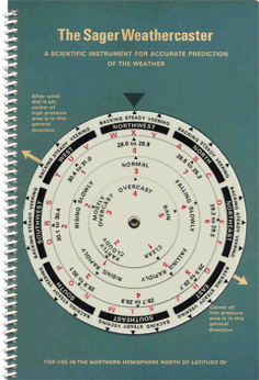
The Sager Weathercaster is an instrument, which allows you to make forecasts of weather, temperature and wind conditions instantly, for a radius of about 50 km of your location. Here You see the Raymond M. Sager and E.F. Sager 1969 edition. However it has been in use since 1942. The Sager Weathercaster is made for use in the Northern Hemisphere. North of Latitude 25°. It is in fact a handy computer, using easily observed weather factors, programmed to yield concise forecasts based on 5000 variations of input data. It embodies the experience gained in more than 35 years of forecasting for private companies and for the US Air Force. With the Sager Weathercaster and correct observations of a barometer, you can make precise and up to the minute forecasts for rapidly changing conditions at your location. Highest accuracy is of course obtained by making forecasts at frequent intervals. |
|
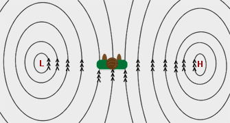
The Sager Weathercaster is based, like the Zambretti Forecaster, on the Buys Ballot's law. This law may be expressed as follows. In the Northern Hemisphere, if a person stands with his back to the wind, the low pressure area will be on his left from 90° to 135°. This is because wind travels counterclockwise around low pressure zones in the Northern Hemisphere. It is approximately true in the higher latitudes of the Northern Hemisphere, and is reversed in the Southern Hemisphere, but this angle is not a right angle in low latitudes. |
|
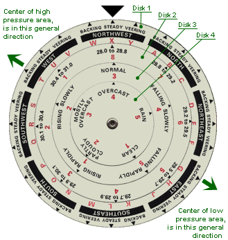
The Sager Weathercaster consists of 4 plastic discs of descending radius, arranged concentrically and secured together with the book by means of a rivet. |
Disc 1: Wind direction combined with change (Backing, Steady, Veering)
Disc 2: Barometric pressure with a limited number of ranges to select from
Disc 3: Rate of change of barometric pressure
Disc 4: The current sky conditions |
|
|
In the instrument image above we have for the wind, NW and steady which gives X, for the pressure, 28.0-28.8 inHg or 948.2-975.3 hPa which gives 8, for the pressure trend, steady which gives 3 and for the sky conditions, overcast which gives 4. These settings translate to a code number X834 which, when looked up in the book, results in the forecast SW8. S for rain or showers followed by improvement (within 12 hours) and becoming cooler, W for dangerous gale with winds from 55 to 73 mph or 91 to 120 km/h) and 8 for Northwest or North winds. Also the low pressure area, lies East Northeast. |
|
|
Weather Predictions |
|
Weather Expected |
|
(First Letter) |
A: Fair
B: Fair and warmer
C: Fair and cooler
D: Unsettled
E: Unsettled and warmer
F: Unsettled and cooler
G: Increasing cloudiness or overcast followed by rain or showers
H: Increasing cloudiness or overcast followed by rain or showers and warmer
J: Showers
K: Showers and warmer
L: Showers and cooler
M: Rain
N: Rain and warmer
P: Rain and turning cooler. Then improvement likely in 24 hours
R: Rain or showers followed by improvement (within 12 hours)
S: Rain or showers followed by improvement (within 12 hours) and becoming cooler
T: Rain or showers followed by improvement early in period (within 6 hours)
U: Rain or showers followed by improvement early in period (within 6 hours) and becoming cooler
W: Rain or showers followed by fair early in period (within 6 hours) and becoming cooler
X: Unsettled followed by fair
Y: Unsettled followed by fair early in period (within 6 hours) and becoming cooler |
|
|
Wind Velocities |
|
(Second Letter) |
The following predictions are velocities to be expected sometime during the next 24 hours.
Winds occasionally may exceed these velocities for short periods.
N: Probably increasing
F: Moderate to fresh (13-24 mph or 20-40 km/h)
S: Strong (25-38 mph or 41-60 km/h). Strong winds may precede gales over open water
G: Gale (39-54 mph or 61-90 km/h)
W: Dangerous gale (55-73 mph or 91-120 km/h)
H: Hurricane (74 mph or 121 km/h and above)
D: Diminishing or moderating somewhat if current winds are of fresh to strong velocity
U: No important change. Some tendency for slight increase in winds during day, diminishing in evening |
|
Wind Direction |
|
(Number) |
Predictions apply for a total period of about 12 hours. When 2 numbers are used, the first number will indicate wind direction for the first several hours and the second number the direction or trend to be expected thereafter.
1: North or Northeast winds
2: Northeast or East winds
3: East or Southeast winds
4: Southeast or South winds
5: South or Southwest winds
6: Southwest or West winds
7: West or Northwest winds
8: Northwest or North winds
9: Shifting or variable winds
Note: Sudden wind squalls sometimes occur at time of wind change from South or Southwest to West or Northwest. |
|
|
The use of a Sager Weathercaster may seem antiquated today, since we have a variety of weather informations and forecasts, straightly, through various means of communication and systems. But in cases where several incidents silence this informations, its existence can be lifesaving. Imagine a sailing boat in the middle of the sea with serious damage on electrical equipment and poor reception even in the possible emergency radio, trying to carve out a safe route amid intense weather. It can only rely on experience and in anything non-electronic available. Because as the experience says... System that not exists, doesn't spoil! |

|


 Saturday 01-08-2026